

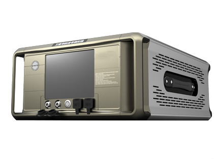
GSY-S-8000 Multi-System Satellite Navigation Signal Simulator
Introduction
GSY-SSS-8000 Multi-System Satellite Navigation Signal Simulator can simulate BDS, GPS, GLONASS and Galileo global satellite positioning system (GPS) satellite navigation signals, can be used for many systems compatible with the terminal equipment development, production, testing, testing and inspection.
Function
1. Frequency points supported by the product include Beidou Satellite Navigation System (BDS), B1, B2, B3, GPS L1 and L2 and L5, GLONASS L1, L2 and Galileo E1, E5a, E5b frequency points (choose 3 to 11 frequency points).
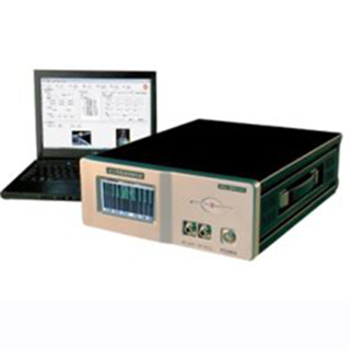
2. Using configuration data simulation software, simulation data can be configured according to user requirements, such as satellite orbit data, ionosphere, tropospheric parameters, and trajectory users.
3. The control software is used to interrupt the output signal of the satellite navigation signal simulator, restore the signal, switch the visible star signals, select the modulation mode, and control the power.
4. Evaluation software can test the receiver’s first positioning, speed, sensitivity and positioning time and other indicators; abnormal conditions can simulate satellite pseudo ranges to test the receiver’s autonomous functions.
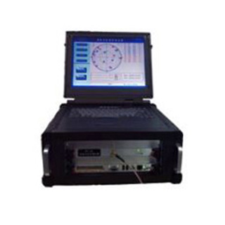
5. LCD display content: carrier information such as satellite number, channel number, analog time, doppler, pseudorange, satellite power, location, and vehicle speed.
6. The navigation signal can be output via cable or antenna.
Optional Configuration
Real-time closed-loop, the real-time closed-loop function is added, the carrier motion trajectory is received in real time, and the satellite navigation data is generated in real time, so as to meet the closed-loop simulation test requirements of real-time hardware in the loop simulation system under multi signal system.
Inertial navigation AIDS, the auxiliary receiver can capture, track and locate in high dynamic, with the addition of inertial navigation aid, synchronous output of 3d position, 3d speed and 3d acceleration with satellite navigation signal.
Multi-path signal, each frequency point can increase the output of 12 multi-path signals and main path signals.
Carrier rotation simulation, when the carrier rotates, the satellite navigation signal changes. In order to make the satellite navigation receive the signal, the equipment fully simulates the real movement in the ground test.
Multiple antennas, increasing the number of simulated antennas, the single simulator can support the simulation of four antennas.
Applications
Satellite navigation terminal equipment research, development, testing
Hardware-in-the-loop simulation system real-time closed-loop test
Type anti-jamming satellite navigation receiver research, development, testing
Orientation, pose measurement equipment research, development, testing and simulation
Features
The basic support of satellite navigation signal simulation BDS, GPS, GLONASS and Galileo system at the same time
The basic support receiver antenna modeling
The basic simulation vector rotation
Inertial aided information output high dynamic scene receiver is required
The basic control software is easy to use, flexible and powerful
Have an evaluation software to evaluate the performance of user machine
The basic simulation with the Beidou satellite navigation system (BDS) P code function
Specifications
-30 dBm ~ 70dBm
Resolution: 0.2db
Calibration accuracy: 0.5dB
Signal output mode
Cable directly or wirelessly
External interface
Rf output: N-type head
External clock input: BNC Female, 10MHz
Internal clock output: BNC Female, 10.23MHz
Second pulse output: BNC Female, 1PPS
Synchronous trigger input/output: BNC Female
External control port: ethernet port
Power features: AC 220V, 50Hz
Physical properties
Dimensions (wide x height x depth): 445mm x 222mm x 611mm
Weight: ≤30kg
Environmental requirements
Working humidity: 75% or less (23 ℃)
Working temperature: 0 ℃ to + 50 ℃
Storage temperature: – 30 ℃ ~ + 70 ℃
Vibration: ≤0.2g/100Hz (maximum)
Transportation requirements: meet the requirements of three levels of road transportation
Reliability
Mean time between failures (MTBF): ≥3000hours
Mean time to repair (MTTR): ≤2hours
A continuous working time: ≥24hours
Computer workstation recommendation configuration
Operating system: windows XP/Windows 7 32bit
Processor: intel @2GHz or higher
External interface: RS232 and gigabit ethernet ports
FAQ:
1. What are the quotation methods?
If you have DHL or Fedex account, we can quote EXW price, otherwise CIF or FOB price.
2. Are there any discounts?
After we submit the sample price, if more quantity is needed, we will quote the bulk price.
3.How long will it take to deliver the goods after placing the order?
For sensors, parts and modules: in stock-one week; no stock-2-4 weeks; For systems, generally, 8-12 weeks.
4.How to deal with the quality problems?
After confirming that the product has quality problems, we will replace it for you free of charge in the shortest possible time.
If interested in Multi-System Satellite Navigation Signal Simulator, pls contact us: info@joinsunny.cn