

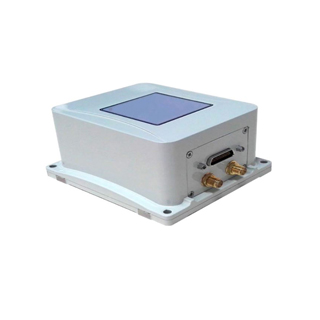
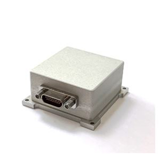
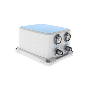
GSY-MINS-5651 High Stability MEMS Inertial/Satellite Integrated Navigation System
Introduction
High Stability MEMS Inertial/Satellite Integrated Navigation System is equipped with micro MEMS gyroscope, accelerometer, and mobile surveying and mappinglevel multimode multi frequency GNSS receiver.
which supports GPS/GLONSS/BD function. The product has excellent integrated navigation performance, and the system size can be reduced to an unprecedented compactness. It can realize dynamic fast alignment or GNSS dual antenna assisted fast and high-precision orientation, and the orientation accuracy can reach 0.1°.
In order to meet the application demand of mobile street view mapping, ocean mapping and other mapping areas, with the original data storage and surveying and mapping level navigation post-processing software, users can choose according to requirements.
The product supports GNSS/odometer/DVL/barometric altimeter and other external sensors, which has excellent scalability. By using multi sensor data fusion technology integrates multi-source data, the system of regional adaptability and robustness has been greatly improved, while it also has AHRS navigation reference function. In the absence of any external assistance, it can achieve long time attitude and heading keeping. It is especially suitable for unmanned aerial vehicles, underwater vehicles and other unmanned aerial vehicle navigation and attitude determination.
Features
Built in surveying and mapping level GNSS receiver: support Beidou B1, B2;
Embedded data fusion algorithm engine SFE for GNSS occlusion, multipath interference is specially optimized;
Post processing software for surveying and mapping level navigation;
Support rapid alignment: dynamic accuracy 0.1°, time 1~2 minutes (dynamic maneuver is needed);
Support low dynamic application environments condition satellite dual antenna aided rapid orientation: accuracy of 0.1°(2m baseline);
Interface: RS232/RS422/LAN/CAN/USB;
Maximum support for 16G data storage extensions, support navigation data/raw data/external user data storage;
Support multiple external sensor combinations (odometer/DVL/barometric altimeter);
NMEA0183 standard protocol output and up to 20 exclusive protocols flexibly available.
Applications
| Space fields | Unmanned aircraft; Aerial surveying; Photoelectric detection stability; Aerostat. |
High dynamic measurement range; Pneumatic altimeter combination; Full temperature calibration compensation (-40~80 ℃); Built-in 16G data storage; INS/GNSS combination design; Optimization vibration environment accuracy. |
| Land-based domain | Street view cart; Electric inspection unmanned car; Intelligent unmanned car; Vehicle-mounted satellite communication. |
Support single antenna mode; Support IE post-processing; Support multiple interface output; Support RTK mobile station; Support NMEA standard protocol. |
Specifications
| System accuracy | |
| Heading | 0.1°(1σ) dynamic alignment 0.1° (1σ) low dynamic dual antenna assistance, 2mbaseline |
| Attitude | 0.1°(1σ) |
| GNSS combined horizontal positioning accuracy | Single point L1/L2: 1.2m (1σ) |
| DGPS | 0.4m(1σ) |
| RTK | 2cm+1ppm(1σ) |
| GNSS combined speed accuracy | 0.02m/s(1σ) |
| Odometer combined positioning accuracy | 1% driven distance (depending on the accuracy of the external odometer) |
| Heaving measurement accuracy | 5cm or 1% |
| Start time | ≤10s |
| Alignment time | 1~2min (depending on the form of dynamic maneuver) |
| Dual antenna assisted directional time | ≤1min |
| Key components parameters | |
| MEMS gyroscope | Range: ±300°/s |
| Zero partial stability | ≤20° /h |
| Accelerometer | Range: ±10g |
| Zero partial stability | ≤1mg |
| User model | |
| Car model (the default model) | Airborne model, ship model |
| Data interface | |
| Serial port | 2path (RS232/RS422 configurable), 1path RS232 |
| CAN2.0b | 1path |
| LAN | 1path |
| Pulse | 1 path differential signal, 2 path single end; Support PPS, EVENTMARK input/output |
| Subsidiary sensors | Odometer/DVL/atmospheric altimeter interface |
| Storage capacity | 16G (customization) |
| Data refreshrate | 200Hz (configurable) |
| Electrical characteristics | |
| Supply voltage | 24VDC rated (12~32VDC) |
| Power consumption | ≤7W |
| Physical characteristics | |
| Outline dimension | 100mm×90mm×50mm |
| Weight | ≤500g |
| Environmental characteristics | |
| Vibration | 20~500Hz, vibration acceleration 5g |
| Impact | 15g |
| Operating temperature | -40℃~+60℃ |
| Protection grade | IP67 |
| Mean Time between Failures | 2000h |
| Optional accessory | |
| Odometer kit | Doppler speed radar/wheel speed sensor |
| Barometric altimeter | 10~1200Hpa, resolution 0.1 Hpa, measurement accuracy 10m (Max) |
| RTK difference station | Digital transmit radio 433 MHz/900MHz/2.4GHz |
| Navigation post-processing software | The processing result can reach the mapping level requirement |
| Antenna specifications | |
| Framing signal | BDS: B1, B2, B3 GPS: L1, L2 GLONASS: G1, G2 Galileo: El, E5b |
| Dimension | Ф31mmx50.39mm |
| Weight | <25g |
FAQ:
1. What are the quotation methods?
If you have DHL or Fedex account, we can quote EXW price, otherwise CIF or FOB price.
2. Are there any discounts?
After we submit the sample price, if more quantity is needed, we will quote the bulk price.
3. How long will it take to deliver the goods after placing the order?
For sensors, parts and modules: in stock-one week; no stock-2-4 weeks; For systems, generally, 8-12 weeks.
4. How to deal with the quality problems?
After confirming that the product has quality problems, we will replace it for you free of charge in the shortest possible time.
If interested in High Stability MEMS Inertial/Satellite Integrated Navigation System, pls contact us: info@joinsunny.cn