

GSY-PMINS Pipe Inertial Mapping System
Introduction
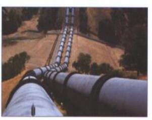
GSY-PMINS Pipe Inertial Mapping System can measure the trajectory, coordinate of oil and gas pipeline, and do meter grade positioning, assisted pipeline safety assessment and damaged point positioning. With the advantages of a highly automatic, low power consumption, long term working and the centimeter grade measurement precision of pipeline deformation. The product has successfully applied in CNOOC, petro china pipeline detection engineering application.
Features
Long time high precision navigation technology (100h+);
High precision correction technology in mark spot;
Spiral trajectory error compensation technology;
Closed pipe “special situation” processing technology;
Pipeline environmental adaptability technology;
Accurate positioning in pipeline surveying and mapping.
Applications
Pipeline detection
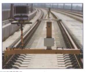
Pipe mapping inertial navigation system
Specifications
Measurement range
| Speed range | -50 m/s~50m/s |
| Pitch angle | ±90° |
| Roll angle | ±180° |
| Heading range | 0°~360° |
Measurement Precision
| Height | ±2m (1σ) |
| Horizontal positioning accuracy (east, north) | ±2m (1σ) |
| Pitch angle (initial alignment) | ±0.15 ° |
| Roll angle (initial alignment) | ±0.15 ° |
| Heading angle (initial alignment) | ±3 ° |
FAQ:
1. What are the quotation methods?
If you have DHL or Fedex account, we can quote EXW price, otherwise CIF or FOB price.
2. Are there any discounts?
After we submit the sample price, if more quantity is needed, we will quote the bulk price.
3. How long will it take to deliver the goods after placing the order?
For sensors, parts and modules: in stock-one week; no stock-2-4 weeks; For systems, generally, 8-12 weeks.
4. How to deal with the quality problems?
After confirming that the product has quality problems, we will replace it for you free of charge in the shortest possible time.
If interested in Pipe Inertial Mapping System, pls contact us: info@joinsunny.cn